. INTRODUCTION
The Yangtze River, which is dominated by the strongest monsoon climate conditions (Fig. 1a), delivers large volumes of water, chemicals and sediment from its headwater regions and tributaries to middle-lower reaches and East China Sea, not only significantly influencing sedimentary system evolution in its drainage basin, but also greatly affect ecological environment and human activities (Wang et al., 2017; Zhang et al., 2015). In addition, over 400 million people – 6.6% of the world's population – lived in the Yangtze River Basin with a catchment of more than 1.8 × 10⁶ km2 (Sun et al., 2016). Particularly, Wuhan area, as the biggest city located middle Yangtze River Basin, has hundreds of lakes and Yangtze River mainstream drained here, is of great significance to understand paleoclimate change and paleo-environment evolution.
Fig. 1
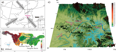
Location of core HH-2017. a) and b) Wuhan area located in middle Yangtze River Basin is dominated by East Asian monsoon; c) map showing hundreds of lakes and rivers developed in Wuhan area; core HH-2017 was drilled in left bank of Yangtze River.

The Holocene is the current geological epoch, and it has seen the growth and impacts of the human species worldwide, including all its written history, development of major civilisations, and overall significant transition toward urban living in the present. During this period, changes of the natural environment and climate play a key role in the development and progress of human civilisation. Thus, effects of Holocene climate change and geo-environmental evolution on human have been received more and more attention (Zhou et al., 2005; Prokopenko et al., 2007; Wallinga, 2010; Ashley et al., 2011; Briner et al., 2016; Marks et al., 2017; Guo et al., 2018). Recently, a high-resolution and accurate geochronological framework of flu-lacustrine sediments, which are important records of paleo-environment and paleoclimate, allows us to understand these phenomena better.
Radiocarbon dating is widely used for lacustrine sediment chronology determination (Long et al., 2011). However, 14C dating of such sediments could be problematic because they often suffer from contamination from sources of ‘old carbon’ (hard water reservoir effect) (Liu et al., 2009) and the reservoir effect (Wang et al., 2007; Queiroz et al., 2018; Xu et al., 2018). In addition, lack of continuous and suitable dating materials also makes it a challenging work to obtain accurate chronologies of fluvial-lacustrine sediment by 14C dating. In nearly two decades, optically stimulated luminescence (OSL) dating had been widely applied to dating lake sediments in order to improve the 14C dating problems (English et al., 2001; Berger and Doran, 2001; Olley et al., 2004; Cupper, 2008; Madsen et al., 2008; Fan et al., 2010; Liu et al., 2009; Shen et al., 2015; Ozcelik, 2016; Hu et al., 2017; Lehmann et al., 2017; Zhao et al., 2015; Ideker et al., 2017; May et al., 2018; Harning et al., 2018).
In this study, we collected 20 samples from the 45 m long Holocene core HH-2017 (30°37’59.20” N, 114°17’21.43” E) in middle Yangtze River Basin, Wuhan area, China for OSL dating, in order to establish high-resolution chronology of flu-lacustrine sediment for better understanding regional paleo-climatic changes and geo-environmental evolution.
. STUDYING AREA, CORING AND SAMPLING
Wuhan area is located eastern Jianghan Basin, middle Yangtze River Basin, Fig. 1b. This region is dominated by the summer monsoon from June to September, which brings most of the moisture for the whole year. In winter, cold and wet continental air mass prevailed in the area. The mean annual temperature of Wuhan is between 13.4°C and 18.5°C while the annual precipitation is about 1300 mm (http://www.hbqx.gov.cn/news.action?id=6530). Subtropical monsoon climate and downland mound make Wuhan area composed of high-density river drainages and numerous lake systems, Fig. 1c. The water covers 1/4 of the land area with more than 2117 km2, including 471 km2 river channel and 868 km2 lacustrine coverage. As a consequence, Wuhan area widely developed 30∼40 m Holocene flu-lacustrine deposits.
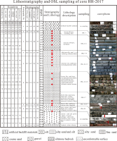
Considering of regional geomorphological/geological setting and human activities, in autumn field work of 2017, a 45 m long core (114°17’21.43” E, 30°37’59.20” N, 26 m above sea level) is extracted from the left bank floodplain, which is 3 km far away from the Yangtze River, Fig. 1c. From bottom upwards the core, the deposits grain size become finer and finer from gravel to silt. It shows a typical flu-lacustrine depo-system and can be divided into 11 layers according to variations in colour, texture and lithology, Fig. 2. Before 4.25 m, it is artificial backfill soil layer while no suitable materials for OSL dating after 38.55 m, thus, 20 samples were collected for OSL dating from 4.25 m to 38.55 m. In practical sampling work, we cannot collect samples with an equal distance because of the unconsolidated formation and partly low core recovery rate, detailed information seen in Fig. 2 and Table 1. To avoid exposure to light, each columnar OSL dating sample were put into an algam-made container just after drilling done.
Fig. 2
Drilling information and profile sketches locating the stratigraphic sampling location for the OSL dating. Before 4.25 m, it is artificial backfill layer while it is gravel layer after 38.55 m; thus, 20 samples totally were collected for OSL dating from 4.25 to 38.55 m.

Table 1
Sample number and its sampling depth as well as environmental radioactivity and OSL dating results of HH-2017.
| Sample ID | Depth (m) | Dating grain size (μm) | K (%) | Th (ppm) | U (ppm) | Water content (%) | No. of aliquots | Dose rate (Gy/ka) | Final De (Gy) | OSL age (ka) |
|---|---|---|---|---|---|---|---|---|---|---|
| HH-2017-01 | 4.25 | 4 ∼ 11 | 2.52 ± 0.07 | 15.70 ± 0.42 | 2.94 ± 0.11 | 29 ± 5 | 11b | 3.1 ± 0.2 | 2.6 ± 0.3 | 0.8 ± 0.1 |
| HH-2017-02 | 5.17 | 4 ∼ 11 | 2.71 ± 0.08 | 15.00 ± 0.40 | 2.66 ± 0.10 | 27 ± 5 | 12b | 3.3 ± 0.2 | 1.1 ± 0.1 | 0.4 ± 0.0 |
| HH-2017-03 | 6.25 | 4 ∼ 11 | 2.45 ± 0.07 | 13.60 ± 0.38 | 3.32 ± 0.13 | 30 ± 5 | 12b | 3.0 ± 0.2 | 2.5 ± 0.1 | 0.8 ± 0.1 |
| HH-2017-04 | 7.25 | 4 ∼ 11 | 2.59 ± 0.08 | 15.60 ± 0.42 | 2.89 ± 0.11 | 35 ± 5 | 12b | 2.8 ± 0.2 | 2.7 ± 0.0 | 1.0 ± 0.1 |
| HH-2017-05 | 8.28 | 4 ∼ 11 | 2.23 ± 0.07 | 14.20 ± 0.38 | 2.40 ± 0.10 | 27 ± 5 | 12b | 2.8 ± 0.2 | 2.2 ± 0.1 | 0.8 ± 0.1 |
| HH-2017-06 | 10.05 | 38 ∼ 63 | 1.75 ± 0.06 | 13.80 ± 0.39 | 2.38 ± 0.10 | 35 ± 5 | 6a+11b | 2.0 ± 0.1 | 8.0 ± 0.2 | 3.9 ± 0.2 |
| HH-2017-07 | 12.56 | 38 ∼ 63 | 2.03 ± 0.06 | 11.40 ± 0.32 | 2.15 ± 0.09 | 26 ± 5 | 6a+12b | 2.4 ± 0.2 | 12.6 ± 0.2 | 5.2 ± 0.4 |
| HH-2017-08 | 13.59 | 38 ∼ 63 | 1.88 ± 0.06 | 12.30 ± 0.34 | 2.13 ± 0.09 | 26 ± 5 | 6a+12b | 2. 4 ± 0.2 | 12.0 ± 0.3 | 5.1 ± 0.4 |
| HH-2017-09 | 14.24 | 38 ∼ 63 | 2.07 ± 0.06 | 14.60 ± 0.39 | 2.40 ± 0.09 | 28 ± 5 | 6a+12b | 2. 6 ± 0.2 | 12.5 ± 0.2 | 4.9 ± 0.4 |
| HH-2017-10 | 15.41 | 90 ∼ 125 | 1.92 ± 0.06 | 10.70 ± 0.31 | 2.11 ± 0.09 | 30 ± 5 | 6a+12b | 2.2 ± 0.2 | 14.0 ± 0.5 | 6.6 ± 0.5 |
| HH-2017-11 | 16.53 | 90 ∼ 125 | 1.65 ± 0.05 | 8.50 ± 0.26 | 1.45 ± 0.07 | 24 ± 5 | 6a+12b | 1.9 ± 0.1 | 12.1 ± 0.3 | 6.3 ± 0.5 |
| HH-2017-12 | 17.70 | 90 ∼ 125 | 1.64 ± 0.05 | 7.90 ± 0.25 | 1.88 ± 0.08 | 25 ± 5 | 6a+12b | 1.9 ± 0.1 | 11.5 ± 0.2 | 6.0 ± 0.4 |
| HH-2017-13 | 18.90 | 90 ∼ 125 | 1.44 ± 0.05 | 12.90 ± 0.36 | 1.97 ± 0.09 | 22 ± 5 | 5a+12b | 2.2 ± 0.2 | 15.3 ± 0.5 | 7.1 ± 0.5 |
| HH-2017-15 | 22.34 | 90 ∼ 125 | 1.50 ± 0.05 | 10.00 ± 0.29 | 1.47 ± 0.07 | 21 ± 5 | 5a+12b | 2.0 ± 0.1 | 11.9 ± 0.4 | 6.1 ± 0.5 |
| HH-2017-17 | 24.74 | 90 ∼ 125 | 1.61 ± 0.05 | 11.00 ± 0.31 | 1.52 ± 0.07 | 24 ± 5 | 6a+11b | 2.0 ± 0.1 | 13.9 ± 0.8 | 6.9 ± 0.6 |
| HH-2017-19 | 27.01 | 90 ∼ 125 | 2.11 ± 0.06 | 6.84 ± 0.23 | 1.12 ± 0.06 | 27 ± 5 | 6a+12b | 2.0 ± 0.2 | 16.0 ± 0.6 | 8.0 ± 0.7 |
| HH-2017-21 | 34.11 | 90 ∼ 125 | 1.69 ± 0.06 | 6.53 ± 0.22 | 1.11 ± 0.06 | 17 ± 5 | 6a+12b | 2.0 ± 0.2 | 16.1 ± 0.8 | 8.2 ± 0.7 |
| HH-2017-22 | 35.26 | 90 ∼ 125 | 2.00 ± 0.06 | 13.50 ± 0.38 | 3.04 ± 0.12 | 21 ± 5 | 6a+12b | 2. 9 ± 0.2 | 28.0 ± 1.0 | 10.0 ± 0.8 |
| HH-2017-23 | 35.95 | 90 ∼ 125 | 1.90 ± 0.06 | 12.50 ± 0.35 | 2.17 ± 0.09 | 22 ± 5 | 6a+12b | 2.6 ± 0.2 | 22.5 ± 0.6 | 8.9 ± 0.7 |
| HH-2017-25 | 38.55 | 90 ∼ 125 | 2.25 ± 0.06 | 7.74 ± 0.25 | 1.40 ± 0.07 | 10 ± 5 | 6a+6b | 2.8 ± 0.2 | 21.8 ± 0.9 | 7.9 ± 0.7 |
. METHODS
Quartz extraction and measurement techniques
Quartz extraction and OSL measurement were conducted in OSL Dating Laboratory, China University of Geosciences (Wuhan). In the laboratory, outermost sediment of each core OSL dating sample was scraped to avoid potential contamination inherited from drilling and sampling. Then, we scraped more outer possible light-exposed materials used for dose rate and water content measurement. The left non-light-exposed materials in the middle part of the container were prepared for quartz extraction.
The non-light-exposed materials were treated firstly with 30% H2O2 and 10% HCl to remove organic materials and carbonates, respectively. For different grain size sedimentary layer, the 4∼11 μm, 38∼63 μm and 90∼125 μm fractions were separated by wet sieving. Especially, the fine silt (4–11 μm) was obtained using sedimentation procedures based on Stokes’ Law (Lu et al., 2007). After that, on the one hand, the 4∼11 μm and the 38∼63 μm fractions were treated with H2SiF6 (38%) for about 2 weeks to corrode feldspars, followed by 10% HCl to remove fluoride precipitates. On the other hand, sodium polytungstate was used to separate the 90∼125 μm materials of the density ranging between 2.62 and 2.70 g/cm−3, and a density of 2.75 g/cm−3 heavy liquid was used to remove heavy minerals. Then the materials were treated with 40% HF for 40 min to remove feldspars and the part of grains affected by alpha particles and were treated with fluorosilicic acid (38%) for about 5 days and followed by 10% HCl for 5 hours. Magnetic minerals of all samples were removed by magnetic selection. The purity of quartz grains was checked by IR (830 nm) stimulation to monitor the presence of feldspar. In addition, X-ray diffraction (XRD) was also applied in order to confirm the lack of feldspar, and the results showed that the quartz content was between 98.7% and 100%. Any samples with obvious infrared stimulated luminescence (IRSL) signals were retreated with H2SiF6 to avoid De underestimated (Lai, 2010). Finally, pure quartz sample of three grain size were washed and cleaned with distilled water, and dried at low temperature. The quartz grains were then mounted on the center part (with a diameter of ∼0.5 cm) of stainless steel disks (with a diameter of 1 cm) using silicone oil.
OSL measurement were made using an automated Risø TL/OSL-DA-20 reader equipped with blue diodes (λ=470 ± 5 nm) and IR laser diodes (λ=880 ± 60 nm). The luminescence was stimulated by blue LEDs at 130°C for 40 s, and detected using a 7.5 mm thick U-340 filter (detection window 275–390 nm) in front of the photo-multiplier tube. 90% diode power was used. Irradiations were carried out using a 90Sr/90Y beta source installed in the Risø reader.
A preheat plateau test and dose recovery test were conducted on sample HH-2017-12 to select a proper preheat temperature. The Des were tested under different preheat temperatures from 160 to 300°C with a 20°C interval, and the results show a De plateau at 240∼280°C (Fig. 3a). A dose recovery test (Murray and Wintle, 2003) were conducted with different preheat temperatures and the ratios of recovered dose to a given dose (16 Gy) showed the preheat temperature of 240 and 280°C are better (Fig. 3b). The stable recycling ratio (Fig. 3c) and relative lower thermal transfer ratio (Fig. 3d) of 260°C further suggested the preheat temperature of 260°C for 10 s for natural and regenerative doses, and cut-heat was at 220°C for 10 s for test doses for quartz. Signals of the first 0.64 s stimulation were integrated for growth curve construction after background subtraction (last 10 seconds). The concentrations of U, Th and K were measured by neutron activation analysis. The cosmic-ray dose rate was estimated for each sample as a function of depth, altitude and geo-magnetic latitude (Prescott and Hutton, 1994). The dose rates are shown in Table 1.
Equivalent dose determination
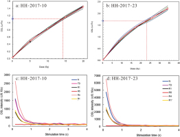
In the current study, the combination of the Single Aliquot Regeneration (SAR) protocol (Murray and Wintle, 2000) and the Standard Growth Curve (SGC) method (Roberts and Duller, 2004; Lai, 2006; Lai et al., 2007; Yu and Lai, 2012, 2014), named as SAR-SGC method (Lai ad Ou, 2013), was employed for De determination. In this method, for each sample, 6–12 aliquots were measured using SAR protocol to get 6–12 growth curves, which were then averaged to construct an SGC for this individual sample, e.g., the SGC of sample HH-2017-10 and HH-2017-23, Fig. 4a and 4b. Then more aliquots were measured to obtain the values of test-dose corrected natural signals only, and each of the values could be matched in the SGC to obtain a De. For each sample, the final De is the average of the SAR Des and SGC Des. The OSL decay curves (Fig. 4c and 4d) decaying to the level of the background within ca. 2 s demonstrate that these signals were mainly from the fast components. Thus, the samples were suitable for OSL dating.
. RESULTS AND DISCUSSIONS
OSL dating results
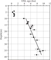
OSL dating results are presented in Table 1 and Fig. 5. The analytical results show that all these ages range from 0.8 ± 0.1 to 7.9 ± 0.7 ka, and most of them follow the stratigraphic sequence within the normal range of error. Disordered OSL dating may be caused by special transport process of flu-lacustrine sediment, especially of “partly re-erosion and re-deposition” in large river depo-system (Kawakami et al., 2004). The borehole drilled nearby mainstream of the Yangtze River is sensitive to the climate and geo-environment change. The sediments could be of fluvial or lacustrine origin under normal conditions, but also may be derived from extreme climate events, such as occasionally short-term flooding. The reversed age to depth might be caused by the quick deposition process, or ages cannot distinguish the deposition time due to the large error in age calculation. But it's worth noting that the age inversions around 20 cm (∼0.8 ka) and 37 cm (∼0.4 ka) core depth may be caused by partly exposure of dating materials. This is because that the dose rate of sample HH-2017-02 is equal to its adjunct samples, but the final De value is half of its adjunct samples. With the similar sampling and preparation process, we proposed that only partly dating materials exposed to light could reduce the final De value, then the younger OSL dating age. However, the results obtained in this study highlight the implication in the application of the OSL dating to flu-lacustrine deposits. The obtained ages also show an increase with depth while the experiments examining luminescence properties are all consistent with the reliable application of the SAR-SGC protocols. In addition, it should be noted that Fig. 5 also exhibits the sediment of HH-2017 mainly deposited in two periods, the first period is from 7. 9 ± 0.7 to 5.2 ± 0.4 ka, while the second period is between 3.9 ± 0.3 and 0.8 ± 0.2 ka. There is an obvious slow deposition period from 5.2 ± 0.4 to 3.9 ± 0.3 ka.
Widespread lake sediment hiatus of the Wuhan area in middle Holocene
Yao et al. (2019) carried out multi AMS 14C dating in various cores in middle and lower reaches of the Yangtze River Basin. Their result combined with previous studies results showed that there was widespread hiatus of sediment during 6∼3 ka in lakes from both sides of the middle and lower reaches of the Yangtze River in Holocene (Boyle et al., 1999; Yang et al., 2004; Yao et al., 2006; Gu et al., 2008; Yao et al., 2015). Based on the reconstructed water level data of the Yangtze River and sea level, the authors proposed that during 6∼3 ka, water level of the Yangtze River was relatively stable, although sediments were accumulated in lakes, they were easy to be eroded and transported due to relatively high elevation of water-sediment and the impact of Yangtze River, resulting in discontinuity of deposition. One of the possible reasons for lake sediment hiatus during this period is that the inflow of sediment in the upper reaches of the Yangtze River decreases and natural levees are easily destroyed, resulting in the deduction of blocking effect on lakes from both sides of the Yangtze River and making lake sediments easily to be eroded into the river (Yao et al., 2019). As located at middle Yangtze River reaches, our OSL dating results of HH-2017 are partly corresponding with the results of previous studies, which demonstrated that our OSL dating results was reliable rather than problematic in experiment and age calculation.
Relationship between lithology change and climate change
Changes in sedimentary lithology and apparent accumulation rate indicate the depositional model change. In millennial-scale, only a minor change showed in tectonic activity and terrain slope, which hardly resulted in such a quickly deposition rate and sedimentary environment change in Wuhan area. Thus, we propose that Holocene climate change and increasing human activity contributes to these phenomena.
At about 21.6 m of HH-2017, the sediment grain size changes from fine sand to silty sand. OSL dating results show that the sedimentary layer deposits between 6.4 and 5.5 ka, which is closely related to Asian summer monsoon weakened period recorded by stalagmite of Heshang cave, Hubei province and Dongge cave, Guizhou province, China from 6.2 to 5.4 ka. (Cosford et al., 2008; Li et al., 2014; Wang et al., 2014; Yun et al., 2015). The paleo-hydrological conditions since 13 ka. in this region based on the synthesis of 4 proxies extracted from the Dajiuhu peatland and above two cave stalagmites show that period of 6.4–5.5 ka is a long-term drier period (Xie et al., 2013, 2015; Zhang et al., 2016). However, it is notable that in the middle Yangtze River region, most drier periods occurred at the warm conditions, different from the cold-drought association in North China. Thus, the climate variation changes the rainfall capacity and surface flow, then the sediment grain size. In addition, high resolution paleoclimate records from pollen, peat, ice core and ocean sediments also indicate that there is a significant climate change during 6∼5 ka, which is also recorded in the HH-2017 lithology change (Qin et al., 2012; Huang et al., 2012; Li et al., 2014; Zhang et al., 2017).
During 5.2∼3.9 ka, there is a slow sediment accumulation in HH-2017. Various stalagmite record in the middle Yangtze River region also indicates that the region is drier at about 4.2 ka (Xie et al., 2015). Rainfall reduction makes both surface flow erosion capacity and river carrying capacity decreased, then less sediment contribution and low depositing rate in this region. In addition, historical documentation also indicates that there is great climate variability between approximately 5∼4 ka all over the world (Mayewski et al., 2004; Daley et al., 2010; Bringué and Rochon, 2012; Litt et al., 2012; Zhu et al., 2017; Huang et al., 2018; Wang et al., 2018; Zhang et al., 2018).
Relationship between lithology change and enhanced human activity
Since 1 ka, rapidly increasing population in middle Yangtze River needs more land to produce food. During the Song dynasty (960–1279 a A.D.) and Ming dynasty (1368–1644 a A.D.), the perennial heavy incursions of the northern nomads resulting in the economic centre moved from north China to middle Yangtze River, and then Wuhan area became the economic centre of the middle reaches of the Yangtze River with its preponderant amphibious transportation (Wang, 1990; Shi, 1991). In addition, Zhang and Zhang (2010) reported that the crop loss was caused by the weather cooling in north China also contributed to the migration of population and economic centre. Agriculture and deforestation are expected to increase the sediment yield, but reservoirs can trap much of this sediment before it reaches the Yangtze River. Consequently, enhanced human activity of reclaiming farmland from lakes make lots of artificial lakes in this area (Zhou and Mi, 1998; Sun et al., 2016). Many studies have recognised that human activities can significantly change the erosion-deposition patterns and rates (Bayon et al., 2012; Hu et al., 2013; He et al., 2014; Reusser et al., 2015; Wan et al., 2015). Thus, lacustrine sediment widely developed in Wuhan area after 1 ka.
. CONCLUSIONS
Luminescence characteristics, including preheat temperature, lab dose recovery, OSL decay and growth curve, and ages distribution show that the OSL signal of flu-lacustrine sediments from core HH-2017 was reset before burial and that OSL dating could have considerable potential for improving the chronology of Holocene flu-lacustrine sediments in Wuhan area.
The good agreement between the OSL ages, stratigraphic sequence, and climate background suggests that OSL dating method could establish significant chronology framework for fluvial sediment in large river drainage, which lack of suitable materials for 14C dating. In addition, relatively high resolution OSL ages of HH-2017 would provide a powerful chronology for reconstructing paleoclimate change and paleo-environment evolution in the Wuhan area, China.


